Total and Diffuse Downward Surface Shortwave Flux - MSG
Abstract:
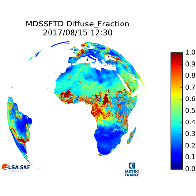
Instantaneous estimate of the total Downwelling Surface Short-wave radiative Flux (DSSF) (W/m2) and the fraction of the diffuse flux component to the total flux. The DSSF refers to the radiative energy in the wavelength interval [0.3 µm, 4.0 µm] reaching the Earth's surface per time and surface unit. An accurate knowledge of the spatio-temporal distribution of downwelling solar radiation and of its diffuse component at the surface are essential for understanding the climate processes at the Earth-atmosphere interface, but also for plant photosynthesis and carbon cycle.
Download plain xml file
To get the data: go to WIS-Portal
Metadata Information
General
| Attribute | Value |
|---|---|
| fileIdentifier/identifier | urn:x-wmo:md:int.eumetsat:EO:EUM:DAT:0270 |
| language | eng |
| characterSet | utf8 |
| hierarchyLevel | series |
| hierarchyLevelName |
|
| contact | see section contact (role: pointOfContact) |
| dateStamp | 2021-03-09 |
| metadataStandardName | WMO Core Metadata Profile of ISO 19115 (WMO Core), 2003/Cor.1:2006 (ISO 19115), 2007 (ISO/TS 19139) |
| metadataStandardVersion | 1.3 |
| referenceSystemInfo | |
| metadataExtensionInfo |
identificationInfo
| Attribute | Value |
|---|---|
| citation | |
| abstract | see above |
| status | onGoing |
| purpose | |
| pointOfContact | see section contact (role: originator) |
| graphicOverview | https://navigator.eumetsat.int/preview/diffuse_dssf.PNG |
| resourceMaintenance |
|
| descriptiveKeywords: |
|
| resourceConstraints |
|
| language | eng |
| characterSet | utf8 |
| topicCategory | climatologyMeteorologyAtmosphere |
| extent | boundingExtent
|
Contact
Role: pointOfContact
| Attribute | Value |
|---|---|
| individualName | EUMETSAT SAF on Land Surface Analysis |
| organisationName | LSA SAF |
| contactInfo |
|
Role: distributor
| Attribute | Value |
|---|---|
| individualName | |
| organisationName | LSA SAF & EUMETSAT |
| positionName | |
| contactInfo |
Role: originator
| Attribute | Value |
|---|---|
| organisationName | LSA SAF |
| contactInfo |
|
contentInfo
| Attribute | Value |
|---|---|
| CoverageDescription: |
|
distributionInfo
| Attribute | Value |
|---|---|
| distributionFormat |
|
| transferOptions (onLine) |
|
dataQualityInfo
| Attribute | Value |
|---|---|
| scope | series |
| report |
|
| lineage |
|