Global Instability K-Index - MSG - Indian Ocean
Abstract:
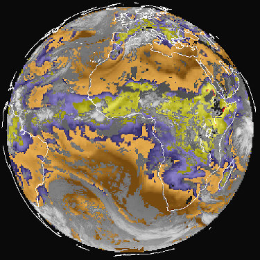
The GII product consists of a set of indices which describe atmospheric air mass instability in cloud free areas. These indices are highly empirical in nature and might even be only relevant in certain geographic regions or under certain circumstances.
The algorithm is a physical retrieval scheme developed at EUMETSAT. Applications and Users: Nowcasting and short term forecasting (up to 12 hours). Resolution is 3x3 pixels.
K-Index is one of the four common instability indices included in GII, and it is defined as follows
K-Index = [ T(850hPa) – T(500hPa) ] + TD(850hPa) – [ T(700hPa) – TD(700hPa) ]
Where T is the ambient temperature at the indicated levels and TD is the ambient dew point temperature at the indicated levels.
From 1 June 2022, Meteosat-9 at 45.5° E is the prime satellite for the IODC service, replacing Meteosat-8 (located at 41.5° E while in operation).
Download plain xml file
To get the data: go to WIS-Portal
Metadata Information
General
| Attribute | Value |
|---|---|
| fileIdentifier/identifier | urn:x-wmo:md:int.eumetsat:EO:EUM:DAT:0328 |
| language | eng |
| characterSet | utf8 |
| hierarchyLevel | series |
| hierarchyLevelName |
|
| contact | see section contact (role: pointOfContact) |
| dateStamp | 2024-01-18 |
| metadataStandardName | WMO Core Metadata Profile of ISO 19115 (WMO Core), 2003/Cor.1:2006 (ISO 19115), 2007 (ISO/TS 19139) |
| metadataStandardVersion | 1.3 |
| referenceSystemInfo | |
| metadataExtensionInfo |
identificationInfo
| Attribute | Value |
|---|---|
| citation | |
| abstract | see above |
| status | onGoing |
| purpose | |
| pointOfContact | see section contact (role: originator) |
| graphicOverview | https://navigator.eumetsat.int/preview/GII_K-ind.jpg |
| resourceMaintenance |
|
| descriptiveKeywords: |
|
| resourceConstraints |
|
| language | eng |
| characterSet | utf8 |
| topicCategory | climatologyMeteorologyAtmosphere |
| extent | boundingExtent
|
Contact
Role: pointOfContact
| Attribute | Value |
|---|---|
| individualName | European Organisation for the Exploitation of Meteorological Satellites |
| organisationName | EUMETSAT |
| contactInfo |
|
Role: distributor
| Attribute | Value |
|---|---|
| individualName | European Organisation for the Exploitation of Meteorological Satellites |
| organisationName | EUMETSAT |
| positionName | |
| contactInfo |
|
Role: originator
| Attribute | Value |
|---|---|
| organisationName | EUMETSAT |
| contactInfo |
|
contentInfo
| Attribute | Value |
|---|---|
| CoverageDescription: |
|
distributionInfo
| Attribute | Value |
|---|---|
| distributionFormat |
|
| transferOptions (onLine) |
|
dataQualityInfo
| Attribute | Value |
|---|---|
| scope | series |
| report |
|
| lineage |
|