MWRI - Feng-Yun - 3 - Regional Data Service
Abstract:
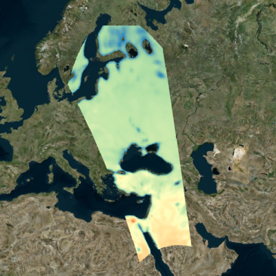
The EARS-MWRI service collects data from the Micro-Wave Radiation Imager (MWRI) instrument, on board the FY-3D spacecraft, operated by CMA.
MWRI is a conical scanning microwave imager at five frequency points with dual polarizations (10 channels); The sensor measures thermal microwave emission of land and ocean surfaces, and measures various forms of water in the atmosphere, clouds, and surfaces.
The MWRI imager can penetrate clouds, providing an all-weather measurement capability. The spatial resolutions are from 12 to 80 km, depending on the wavelengths. At higher-frequency channels, such as 89 GHz, the scattering signature from the cloud and precipitation are also good indicators for detecting rainfall over land and ocean.
Download plain xml file
To get the data: go to WIS-Portal
Metadata Information
General
| Attribute | Value |
|---|---|
| fileIdentifier/identifier | urn:x-wmo:md:int.eumetsat:EO:EUM:DAT:0384 |
| language | eng |
| characterSet | utf8 |
| hierarchyLevel | series |
| hierarchyLevelName |
|
| contact | see section contact (role: pointOfContact) |
| dateStamp | 2023-02-23 |
| metadataStandardName | WMO Core Metadata Profile of ISO 19115 (WMO Core), 2003/Cor.1:2006 (ISO 19115), 2007 (ISO/TS 19139) |
| metadataStandardVersion | 1.3 |
| referenceSystemInfo | |
| metadataExtensionInfo |
identificationInfo
| Attribute | Value |
|---|---|
| citation | |
| abstract | see above |
| status | |
| purpose | |
| pointOfContact | see section contact (role: originator) |
| graphicOverview | https://navigator.eumetsat.int/preview/MWRI.png |
| resourceMaintenance |
|
| descriptiveKeywords: |
|
| resourceConstraints |
|
| language | eng |
| characterSet | utf8 |
| topicCategory | climatologyMeteorologyAtmosphere |
| extent | boundingExtent
|
Contact
Role: pointOfContact
| Attribute | Value |
|---|---|
| individualName | European Organisation for the Exploitation of Meteorological Satellites |
| organisationName | EUMETSAT |
| contactInfo |
|
Role: distributor
| Attribute | Value |
|---|---|
| individualName | European Organisation for the Exploitation of Meteorological Satellites |
| organisationName | EUMETSAT |
| positionName | |
| contactInfo |
|
Role: originator
| Attribute | Value |
|---|---|
| organisationName | EUMETSAT |
| contactInfo |
|
contentInfo
| Attribute | Value |
|---|---|
| CoverageDescription: |
|
distributionInfo
| Attribute | Value |
|---|---|
| distributionFormat |
|
| transferOptions (onLine) |
|
dataQualityInfo
| Attribute | Value |
|---|---|
| scope | series |
| report |
|
| lineage |
|