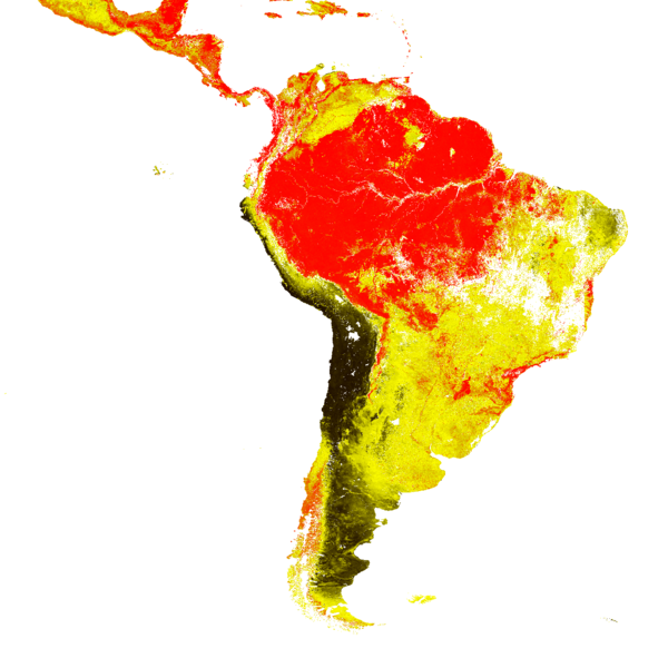
Fraction of Absorbed Photosynthetically Active Radiation - Sentinel-3 - South America
Abstract:
The FAPAR quantifies the fraction of the solar radiation absorbed by plants for photosynthesis. It refers only to the green and living elements of the canopy. The FAPAR depends on the canopy structure, vegetation element optical properties, atmospheric conditions and angular configuration. To overcome this latter dependency, a daily integrated FAPAR value is assessed. FAPAR is very useful as input to a number of primary productivity models and is recognized as an Essential Climate Variable (ECV) by the Global Climate Observing System (GCOS).
From the available global product, this product is a geographic subset over South America. Access to Copernicus Land Service products is free and open to all users.
Download plain xml file
To get the data: go to WIS-Portal
Metadata Information
General
| Attribute | Value |
|---|---|
| fileIdentifier/identifier | urn:x-wmo:md:int.eumetsat:EO:EUM:DAT:0562 |
| language | eng |
| characterSet | utf8 |
| hierarchyLevel | series |
| hierarchyLevelName |
|
| contact | see section contact (role: pointOfContact) |
| dateStamp | 2022-03-09 |
| metadataStandardName | WMO Core Metadata Profile of ISO 19115 (WMO Core), 2003/Cor.1:2006 (ISO 19115), 2007 (ISO/TS 19139) |
| metadataStandardVersion | 1.3 |
| referenceSystemInfo | |
| metadataExtensionInfo |
identificationInfo
| Attribute | Value |
|---|---|
| citation | |
| abstract | see above |
| status | |
| purpose | |
| pointOfContact | see section contact (role: originator) |
| graphicOverview | https://navigator.eumetsat.int/preview/c_gls_FAPAR300-RT6_QL_202111100000_SOAM_OLCI_V1_1_2.png |
| resourceMaintenance |
|
| descriptiveKeywords: |
|
| resourceConstraints |
|
| language | eng |
| characterSet | utf8 |
| topicCategory | climatologyMeteorologyAtmosphere |
| extent | boundingExtent
|
Contact
Role: pointOfContact
| Attribute | Value |
|---|---|
| individualName | EC Copernicus Global Land Service, operated by VITO |
| organisationName | VITO |
| contactInfo |
|
Role: distributor
| Attribute | Value |
|---|---|
| individualName | |
| organisationName | VITO & EUMETSAT |
| positionName | |
| contactInfo |
Role: originator
| Attribute | Value |
|---|---|
| organisationName | VITO |
| contactInfo |
|
contentInfo
| Attribute | Value |
|---|---|
| CoverageDescription: |
|
distributionInfo
| Attribute | Value |
|---|---|
| distributionFormat |
|
| transferOptions (onLine) |
|
dataQualityInfo
| Attribute | Value |
|---|---|
| scope | series |
| report |
|
| lineage |
|