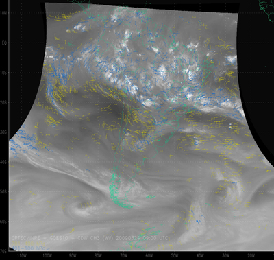
Wind Chart Water Vapour - GOES - South America
Abstract:
These models use the visible (0,5µm), near infrared (3,9µm), water vapor (WV - 6,7µm) and infrared (IR-10,2µm) channels. Visible and near infrared Cloud Drift Winds (CDW) models are used to estimate winds in lower atmospheric levels while the IR and WV models are used to estimate wind in the low, middle and high levels(100-400/401-700/701-100hPa). Using GOES-10 INPE/CPTEC began to produce operationally cloud drift wind, each 15 minutes, for the four channels described above.
Download plain xml file
To get the data: go to WIS-Portal
Metadata Information
General
| Attribute | Value |
|---|---|
| fileIdentifier/identifier | urn:x-wmo:md:int.eumetsat:EO:EUM:DAT:GOES:GWW |
| language | eng |
| characterSet | utf8 |
| hierarchyLevel | series |
| hierarchyLevelName |
|
| contact | see section contact (role: pointOfContact) |
| dateStamp | 2019-09-10 |
| metadataStandardName | WMO Core Metadata Profile of ISO 19115 (WMO Core), 2003/Cor.1:2006 (ISO 19115), 2007 (ISO/TS 19139) |
| metadataStandardVersion | 1.3 |
| referenceSystemInfo | |
| metadataExtensionInfo |
identificationInfo
| Attribute | Value |
|---|---|
| citation | |
| abstract | see above |
| status | |
| purpose | |
| pointOfContact | see section contact (role: originator) |
| graphicOverview | https://navigator.eumetsat.int/preview/GWW.jpg |
| resourceMaintenance |
|
| descriptiveKeywords: |
|
| resourceConstraints |
|
| language | eng |
| characterSet | utf8 |
| topicCategory | climatologyMeteorologyAtmosphere |
| extent | boundingExtent
|
Contact
Role: pointOfContact
| Attribute | Value |
|---|---|
| individualName | National Institute for Space Research |
| organisationName | INPE/CPTEC |
| contactInfo |
|
Role: distributor
| Attribute | Value |
|---|---|
| individualName | National Institute for Space Research |
| organisationName | INPE/CPTEC |
| positionName | |
| contactInfo |
|
Role: originator
| Attribute | Value |
|---|---|
| organisationName | INPE/CPTEC |
| contactInfo |
|
contentInfo
| Attribute | Value |
|---|---|
| CoverageDescription: |
|
distributionInfo
| Attribute | Value |
|---|---|
| distributionFormat |
|
| transferOptions (onLine) |
|
dataQualityInfo
| Attribute | Value |
|---|---|
| scope | series |
| report |
|
| lineage |
|