Evapotranspiration - MSG - 0 degree
Abstract:
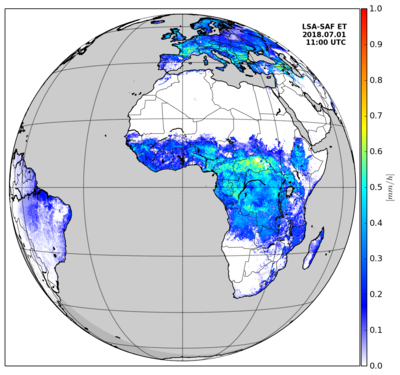
Evapotranspiration (ET) accounts for the flux of water evaporated at the Earth-atmosphere interface (from soil, water bodies and interception) and transpired by vegetation through stomata in its leaves as a consequence of photosynthetic processes. ET is an important component of the water cycle and it is associated with the latent heat flux (LE), a key link between the energy and water cycles. In other words, LE represents the energy needed for the ET process. Evaluating energy fluxes at the Earth surface is of great importance in many disciplines like weather forecasting, global climate monitoring, water management, agriculture and ecology. The ET product contains instantaneous values of evapotranspiration (in mm/h) plus an associated quality flag. ET output is generated in HDF5 format and relevant information for data processing is included in the HDF5 file attributes. Currently ET maps are generated every 30 minutes for the European window with the MSG spatial resolution.
Download plain xml file
To get the data: go to WIS-Portal
Metadata Information
General
| Attribute | Value |
|---|---|
| fileIdentifier/identifier | urn:x-wmo:md:int.eumetsat:EO:EUM:DAT:MSG:ET-SEVIRI |
| language | eng |
| characterSet | utf8 |
| hierarchyLevel | series |
| hierarchyLevelName |
|
| contact | see section contact (role: pointOfContact) |
| dateStamp | 2020-11-16 |
| metadataStandardName | WMO Core Metadata Profile of ISO 19115 (WMO Core), 2003/Cor.1:2006 (ISO 19115), 2007 (ISO/TS 19139) |
| metadataStandardVersion | 1.3 |
| referenceSystemInfo | |
| metadataExtensionInfo |
identificationInfo
| Attribute | Value |
|---|---|
| citation | |
| abstract | see above |
| status | Discontinued |
| purpose | |
| pointOfContact | see section contact (role: originator) |
| graphicOverview | https://navigator.eumetsat.int/preview/HDF5_LSASAF_MSG_ET_MSG-Disk.png |
| resourceMaintenance |
|
| descriptiveKeywords: |
|
| resourceConstraints |
|
| language | eng |
| characterSet | utf8 |
| topicCategory | climatologyMeteorologyAtmosphere |
| extent | boundingExtent
|
Contact
Role: pointOfContact
| Attribute | Value |
|---|---|
| individualName | EUMETSAT SAF on Land Surface Analysis |
| organisationName | LSA SAF |
| contactInfo |
|
Role: distributor
| Attribute | Value |
|---|---|
| individualName | EUMETSAT SAF on Land Surface Analysis |
| organisationName | LSA SAF |
| positionName | |
| contactInfo |
|
Role: originator
| Attribute | Value |
|---|---|
| organisationName | LSA SAF |
| contactInfo |
|
contentInfo
| Attribute | Value |
|---|---|
| CoverageDescription: |
|
distributionInfo
| Attribute | Value |
|---|---|
| distributionFormat |
|
| transferOptions (onLine) |
|
dataQualityInfo
| Attribute | Value |
|---|---|
| scope | series |
| report |
|
| lineage |
|