High Resolution Precipitation Index - MSG - 0 degree
Abstract:
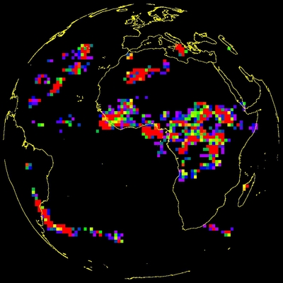
The High Resolution Precipitation Index (HPI) generation is based on the relationship between the channel top-of-atmosphere (TOA) radiance equivalent black body temperature (EBBT) of clouds and convective rainfall. The idea of this relationship is that clouds with cold tops are convective rain-bearing clouds. The scheme is a cloud indexing method based on the pixel values of an IR channel. It estimates an hourly accumulated precipitation. The final HPI product is sent to the UMARF once a day and stored. Applications and Users: Climate research by the WMO's Global Precipitation Climatology Project (GPCP).
Download plain xml file
To get the data: go to WIS-Portal
Metadata Information
General
| Attribute | Value |
|---|---|
| fileIdentifier/identifier | urn:x-wmo:md:int.eumetsat:EO:EUM:DAT:MSG:HPI |
| language | eng |
| characterSet | utf8 |
| hierarchyLevel | series |
| hierarchyLevelName |
|
| contact | see section contact (role: pointOfContact) |
| dateStamp | 2024-01-18 |
| metadataStandardName | WMO Core Metadata Profile of ISO 19115 (WMO Core), 2003/Cor.1:2006 (ISO 19115), 2007 (ISO/TS 19139) |
| metadataStandardVersion | 1.3 |
| referenceSystemInfo | |
| metadataExtensionInfo |
identificationInfo
| Attribute | Value |
|---|---|
| citation | |
| abstract | see above |
| status | onGoing |
| purpose | |
| pointOfContact | see section contact (role: originator) |
| graphicOverview | https://navigator.eumetsat.int/preview/msghpi.jpg |
| resourceMaintenance |
|
| descriptiveKeywords: |
|
| resourceConstraints |
|
| language | eng |
| characterSet | utf8 |
| topicCategory | climatologyMeteorologyAtmosphere |
| extent | boundingExtent
|
Contact
Role: pointOfContact
| Attribute | Value |
|---|---|
| individualName | European Organisation for the Exploitation of Meteorological Satellites |
| organisationName | EUMETSAT |
| contactInfo |
|
Role: distributor
| Attribute | Value |
|---|---|
| individualName | European Organisation for the Exploitation of Meteorological Satellites |
| organisationName | EUMETSAT |
| positionName | |
| contactInfo |
|
Role: originator
| Attribute | Value |
|---|---|
| organisationName | EUMETSAT |
| contactInfo |
|
contentInfo
| Attribute | Value |
|---|---|
| CoverageDescription: |
|
distributionInfo
| Attribute | Value |
|---|---|
| distributionFormat |
|
| transferOptions (onLine) |
|
dataQualityInfo
| Attribute | Value |
|---|---|
| scope | series |
| report |
|
| lineage |
|