Reference Evapotranspiration - MSG
Abstract:
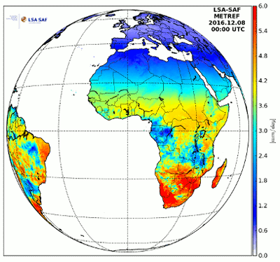
Reference evapotranspiration, ETo, is the evapotranspiration rate from a clearly defined reference surface. The concept was introduced to allow the estimation of the evaporative demand of the atmosphere independently of crop type, crop development or management practices. ETo corresponds to the evapotranspiration from a hypothetical extensive well-watered field covered with 12 cm height green grass having an albedo of 0.23 would experience under the given down-welling short-wave radiation.
Download plain xml file
To get the data: go to WIS-Portal
Metadata Information
General
| Attribute | Value |
|---|---|
| fileIdentifier/identifier | urn:x-wmo:md:int.eumetsat:EO:EUM:DAT:MSG:LSA-303 |
| language | eng |
| characterSet | utf8 |
| hierarchyLevel | series |
| hierarchyLevelName |
|
| contact | see section contact (role: pointOfContact) |
| dateStamp | 2021-09-30 |
| metadataStandardName | WMO Core Metadata Profile of ISO 19115 (WMO Core), 2003/Cor.1:2006 (ISO 19115), 2007 (ISO/TS 19139) |
| metadataStandardVersion | 1.3 |
| referenceSystemInfo | |
| metadataExtensionInfo |
identificationInfo
| Attribute | Value |
|---|---|
| citation | |
| abstract | see above |
| status | |
| purpose | |
| pointOfContact | see section contact (role: originator) |
| graphicOverview | https://navigator.eumetsat.int/preview/etref.png |
| resourceMaintenance |
|
| descriptiveKeywords: |
|
| resourceConstraints |
|
| language | eng |
| characterSet | utf8 |
| topicCategory | climatologyMeteorologyAtmosphere |
| extent | boundingExtent
|
Contact
Role: pointOfContact
| Attribute | Value |
|---|---|
| individualName | EUMETSAT SAF on Land Surface Analysis |
| organisationName | LSA SAF |
| contactInfo |
|
Role: distributor
| Attribute | Value |
|---|---|
| individualName | |
| organisationName | LSA SAF & EUMETSAT |
| positionName | |
| contactInfo |
Role: originator
| Attribute | Value |
|---|---|
| organisationName | LSA SAF |
| contactInfo |
|
contentInfo
| Attribute | Value |
|---|---|
| CoverageDescription: |
|
distributionInfo
| Attribute | Value |
|---|---|
| distributionFormat |
|
| transferOptions (onLine) |
|
dataQualityInfo
| Attribute | Value |
|---|---|
| scope | series |
| report |
|
| lineage |
|