Polar Winds - Multimission
Abstract:
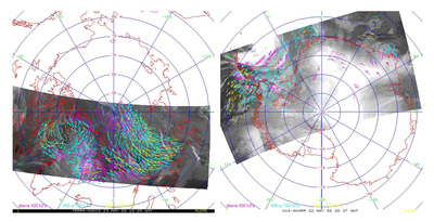
MODIS and AVHRR data are used to retrieve tropospheric winds (speed, direction, and height) in the polar regions by tracking cloud and water vapour features. Much of this information cannot be generated fast enough for use in early NWP model runs due to the delay in obtaining MODIS and AVHRR data (typically 1-4 hrs). To improve the timeliness of the wind data, direct broadcast (DB) sites provide real-time access to water vapour winds (wvap) bufr files from MODIS data, as well as IR cloud-drift winds (cdft) bufr files from both MODIS and AVHRR data.
Download plain xml file
To get the data: go to WIS-Portal
Metadata Information
General
| Attribute | Value |
|---|---|
| fileIdentifier/identifier | urn:x-wmo:md:int.eumetsat:EO:EUM:DAT:MULT:DBWINDS |
| language | eng |
| characterSet | utf8 |
| hierarchyLevel | series |
| hierarchyLevelName |
|
| contact | see section contact (role: pointOfContact) |
| dateStamp | 2020-11-16 |
| metadataStandardName | WMO Core Metadata Profile of ISO 19115 (WMO Core), 2003/Cor.1:2006 (ISO 19115), 2007 (ISO/TS 19139) |
| metadataStandardVersion | 1.3 |
| referenceSystemInfo | |
| metadataExtensionInfo |
identificationInfo
| Attribute | Value |
|---|---|
| citation | |
| abstract | see above |
| status | |
| purpose | |
| pointOfContact | see section contact (role: originator) |
| graphicOverview | https://navigator.eumetsat.int/preview/modis_winds.jpg |
| resourceMaintenance |
|
| descriptiveKeywords: |
|
| resourceConstraints |
|
| language | eng |
| characterSet | utf8 |
| topicCategory | climatologyMeteorologyAtmosphere |
| extent | boundingExtent
|
Contact
Role: pointOfContact
| Attribute | Value |
|---|---|
| individualName | Cooperative Institute for Meteorological Satellite Studies |
| organisationName | CIMSS |
| contactInfo |
|
Role: distributor
| Attribute | Value |
|---|---|
| individualName | Cooperative Institute for Meteorological Satellite Studies |
| organisationName | CIMSS |
| positionName | |
| contactInfo |
|
Role: originator
| Attribute | Value |
|---|---|
| organisationName | CIMSS |
| contactInfo |
|
contentInfo
| Attribute | Value |
|---|---|
| CoverageDescription: |
|
distributionInfo
| Attribute | Value |
|---|---|
| distributionFormat |
|
| transferOptions (onLine) |
|
dataQualityInfo
| Attribute | Value |
|---|---|
| scope | series |
| report |
|
| lineage |
|