Global Low Resolution Sea Ice Drift - Multimission
Abstract:
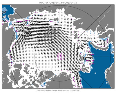
Low Resolution Sea Ice Drift product covers both Northern Hemisphere (NH) and Southern Hemisphere (SH), all year round. Ice motion vectors with a time span of 48 hours are estimated by an advanced cross-correlation method (the Continuous MCC, CMCC) from pairs of passive and active microwave satellite images. Several single-sensor products are available, as well as a merged (multi-sensor) product. Maps of uncertainties are embedded in the product files. Due to higher atmospheric wetness and sea ice surface melting, it is more challenging to track ice motion during summer. Accordingly, the NH product files distributed between 1 May and 30 September have larger uncertainties and more interpolated vectors. The same holds for the SH product files between 1 November and 30 March.
Download plain xml file
To get the data: go to WIS-Portal
Metadata Information
General
| Attribute | Value |
|---|---|
| fileIdentifier/identifier | urn:x-wmo:md:int.eumetsat:EO:EUM:DAT:MULT:GBL-LR-SIDR |
| language | eng |
| characterSet | utf8 |
| hierarchyLevel | series |
| hierarchyLevelName |
|
| contact | see section contact (role: pointOfContact) |
| dateStamp | 2023-10-03 |
| metadataStandardName | WMO Core Metadata Profile of ISO 19115 (WMO Core), 2003/Cor.1:2006 (ISO 19115), 2007 (ISO/TS 19139) |
| metadataStandardVersion | 1.3 |
| referenceSystemInfo | |
| metadataExtensionInfo |
identificationInfo
| Attribute | Value |
|---|---|
| citation |
|
| abstract | see above |
| status | onGoing |
| purpose | |
| pointOfContact | see section contact (role: originator) |
| graphicOverview | https://navigator.eumetsat.int/preview/LR-ICE-DRIFT-OSI-405.jpg |
| resourceMaintenance |
|
| descriptiveKeywords: |
|
| resourceConstraints |
|
| language | eng |
| characterSet | utf8 |
| topicCategory | climatologyMeteorologyAtmosphere |
| extent | boundingExtent
|
Contact
Role: pointOfContact
| Attribute | Value |
|---|---|
| individualName | EUMETSAT SAF on Ocean and Sea Ice |
| organisationName | OSI SAF |
| contactInfo |
|
Role: distributor
| Attribute | Value |
|---|---|
| individualName | European Organisation for the Exploitation of Meteorological Satellites |
| organisationName | EUMETSAT |
| positionName | |
| contactInfo |
|
Role: originator
| Attribute | Value |
|---|---|
| organisationName | OSI SAF |
| contactInfo |
|
contentInfo
| Attribute | Value |
|---|---|
| CoverageDescription: |
|
distributionInfo
| Attribute | Value |
|---|---|
| distributionFormat |
|
| transferOptions (onLine) |
|
dataQualityInfo
| Attribute | Value |
|---|---|
| scope | series |
| report |
|
| lineage |
|