Fraction of Green Vegetation Cover V2 - PROBA-V - South America
Abstract:
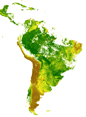
The Fraction of Vegetation Cover (FCover) corresponds to the fraction of ground covered by green vegetation. Practically, it quantifies the spatial extent of the vegetation. Because it is independent from the illumination direction and it is sensitive to the vegetation amount, FCover is a very good candidate for the replacement of classical vegetation indices for the monitoring of ecosystems. The FCover 1km version 2 product is derived by first calculating instantaneous estimates using a neural network and calibrated daily Top of the Canopy reflectances as input. In a second step these instantaneous estimates are composited using an asymmetric period and performing a temporal smooth and gap fill operation based on the land cover type (Evergreen Broadleaf Forest or not).
Download plain xml file
To get the data: go to WIS-Portal
Metadata Information
General
| Attribute | Value |
|---|---|
| fileIdentifier/identifier | urn:x-wmo:md:int.eumetsat:EO:EUM:DAT:PROBA-V:FCOVERSA-V2 |
| language | eng |
| characterSet | utf8 |
| hierarchyLevel | series |
| hierarchyLevelName |
|
| contact | see section contact (role: pointOfContact) |
| dateStamp | 2021-11-09 |
| metadataStandardName | WMO Core Metadata Profile of ISO 19115 (WMO Core), 2003/Cor.1:2006 (ISO 19115), 2007 (ISO/TS 19139) |
| metadataStandardVersion | 1.3 |
| referenceSystemInfo | |
| metadataExtensionInfo |
identificationInfo
| Attribute | Value |
|---|---|
| citation | |
| abstract | see above |
| status | |
| purpose | |
| pointOfContact | see section contact (role: originator) |
| graphicOverview | https://navigator.eumetsat.int/preview/FCOVER.png |
| resourceMaintenance |
|
| descriptiveKeywords: |
|
| resourceConstraints |
|
| language | eng |
| characterSet | utf8 |
| topicCategory | climatologyMeteorologyAtmosphere |
| extent | boundingExtent
|
Contact
Role: pointOfContact
| Attribute | Value |
|---|---|
| individualName | EC Copernicus Global Land Service, operated by VITO |
| organisationName | VITO |
| contactInfo |
|
Role: distributor
| Attribute | Value |
|---|---|
| individualName | |
| organisationName | VITO & EUMETSAT |
| positionName | |
| contactInfo |
Role: originator
| Attribute | Value |
|---|---|
| organisationName | VITO |
| contactInfo |
|
contentInfo
| Attribute | Value |
|---|---|
| CoverageDescription: |
|
distributionInfo
| Attribute | Value |
|---|---|
| distributionFormat |
|
| transferOptions (onLine) |
|
dataQualityInfo
| Attribute | Value |
|---|---|
| scope | series |
| report |
|
| lineage |
|